Results
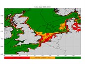
Figure: Pilot assessment of chlorophyll-a at high spatial resolution using satellite data and novel proposed threshold values. Circles represent the assessment results at monitoring locations, using local in situ data. Lines indicate traditional OSPAR (Convention for the Protection of the Marine Environment of the North-East Atlantic) assessment areas for eutrophication.
New perspectives with satellite observation
The project has developed a new coherent method for monitoring and assessment of eutrophication in the North Sea. This includes:
1. Threshold values for Good Environmental Status (GES) for nutrients and chlorophyll a concentrations (Activity 1 report);
2. Multi-algorithm satellite-based chlorophyll-a product (Activity 2 report);
3. Cross-border assessment areas with similar ecological and physical functioning (Activity 1 report);
4. Pilot assessment using the new assessment framework (Activity 2 report);
5. Options for operational collaboration between North Sea countries to improve coherence in their monitoring programmes. This includes collection of validation data for satellite products (Activity 3 report).
Furthermore, the project investigated how satellites can estimate primary production, a potential indicator for food webs and eutrophication (Activity 1 report). During the project a new North Sea Ferrybox line was initiated, that will contribute to chlorophyll-a monitoring, including in water samples.
Coherent method inspires OSPAR
The JMP EUNOSAT approach has in principle been approved in OSPAR and its application will be trialed in the next eutrophication assessment for the Quality Status Report 2023. This includes testing of the project outcomes, in particular the background and threshold concentrations for nutrients and chlorophyll-a, the assessment areas and the consequences of using satellite data.
The JMP EUNOSAT summary report brings together the main results, conclusions and recommendations. Detailed information is given in the Activity reports, given in the links on the right.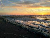
Sea foam (The Hague, May 2019)
> back to JMP EUNOSAT homepage